


I Simulated 38,612 Countryle Games to Find the Best Strategy
I have always enjoyed geography games. For a long time I was obsessed with GeoGuessr, and more recently I got pulled into the collection of daily geography puzzles on the web. Games like Globle, Travle, and Countryle all test your geographic intuition in different ways, asking you to use hints and spatial reasoning to work your way toward the correct country.
Today's game really challenged my lacking West-Africa geography knowledge.
In Countryle, after entering a country, the game tells you in which cardinal direction the target lies. It also reveals whether you matched the correct continent or hemisphere, and whether the target country is larger or smaller in population and warmer or colder in average temperature.
While playing, I kept asking myself the same questions: Is there a best opening guess? And once I got the feedback, what is the best next move?
Reverse engineering the game
The easiest way to “solve” Countryle is to decrypt the daily target country string the backend provides the frontend with. Since everything else from there on happens in the browser, the decryption key has to be shipped somewhere in the JavaScript bundle.
That route is possible, but it is also boring. I wanted to solve the game the same way a player does: only using the feedback that appears after each guess. So instead of reading the answer directly, I extracted the dataset that Countryle uses internally and rebuilt the decision process from scratch.
Countryle’s feedback is provided through five channels:
- Cardinal direction: north, south, east, west, and the diagonal directions.
- Continent: whether the guessed country shares the target’s continent.
- Hemisphere: whether the guessed country shares the target’s hemisphere.
- Population: whether the target is smaller, larger, or close in size.
- Average temperature: whether the target is colder, warmer, or close in value.
For population and temperature, the game effectively operates with buckets. In my solver these become three states: wrong, close, and correct. wrong, indicated by Countryle in red, means the target lies clearly outside the tolerance range, close, depicted with yellow, means it is in the broader neighborhood, and the green correct means it falls within a narrow band around the true value. These buckets matter because they determine how aggressively the remaining search space can be filtered after each guess.
Not all feedback channels are equally valuable. Hemisphere is useful once, but afterwards it often becomes irrelevant. That's also why I excluded it from any of the following figures. Continent can be highly informative when it isolates a small region, but much less so when the result is something like Africa, which still leaves dozens of possibilities. Direction, temperature, and population tend to carry much more granular information, especially when combined.
Turning Countryle into a solver
I built five modules, one for each feedback type. Each module has two jobs.
- Filter: remove countries that are inconsistent with the feedback we just received. If Countryle says the target country is west of Bulgaria, every country that is not west of Bulgaria can be discarded immediately.
- Score: among the remaining candidates, pick the next country that is expected to reveal the most information.
The filter always runs first. The scorer only decides what to guess next after the candidate list has already been reduced. This separation made the whole pipeline modular: I could enable or disable individual feedback channels, compare their usefulness, and later reuse the same logic in an automated bot.
Here, the target country to find is Namibia and I set my solver to start in Canada. Each globe uses a different module.
The real question, then, is how to define “most informative”. My choice was Shannon entropy. In this context, entropy measures how evenly a guess splits the possible outcomes. A guess is good when its possible responses are well spread out, because any answer we get will eliminate a large portion of the remaining countries.
Imagine opening with Norway. For many targets, the cardinal direction feedback will simply be some variation of “south”, which is not especially revealing. A much better guess is a country whose feedback distribution is balanced across many possible directions. That kind of guess creates more informative answers, and entropy captures exactly that.
I have plotted the cardinal direction feedback distribution for every country, and computed the corresponding entropy values.
It turns out that when it comes to cardinal direction feedback, Greece most evenly splits the world. That makes it a very strong guess if you want to get good directional feedback.
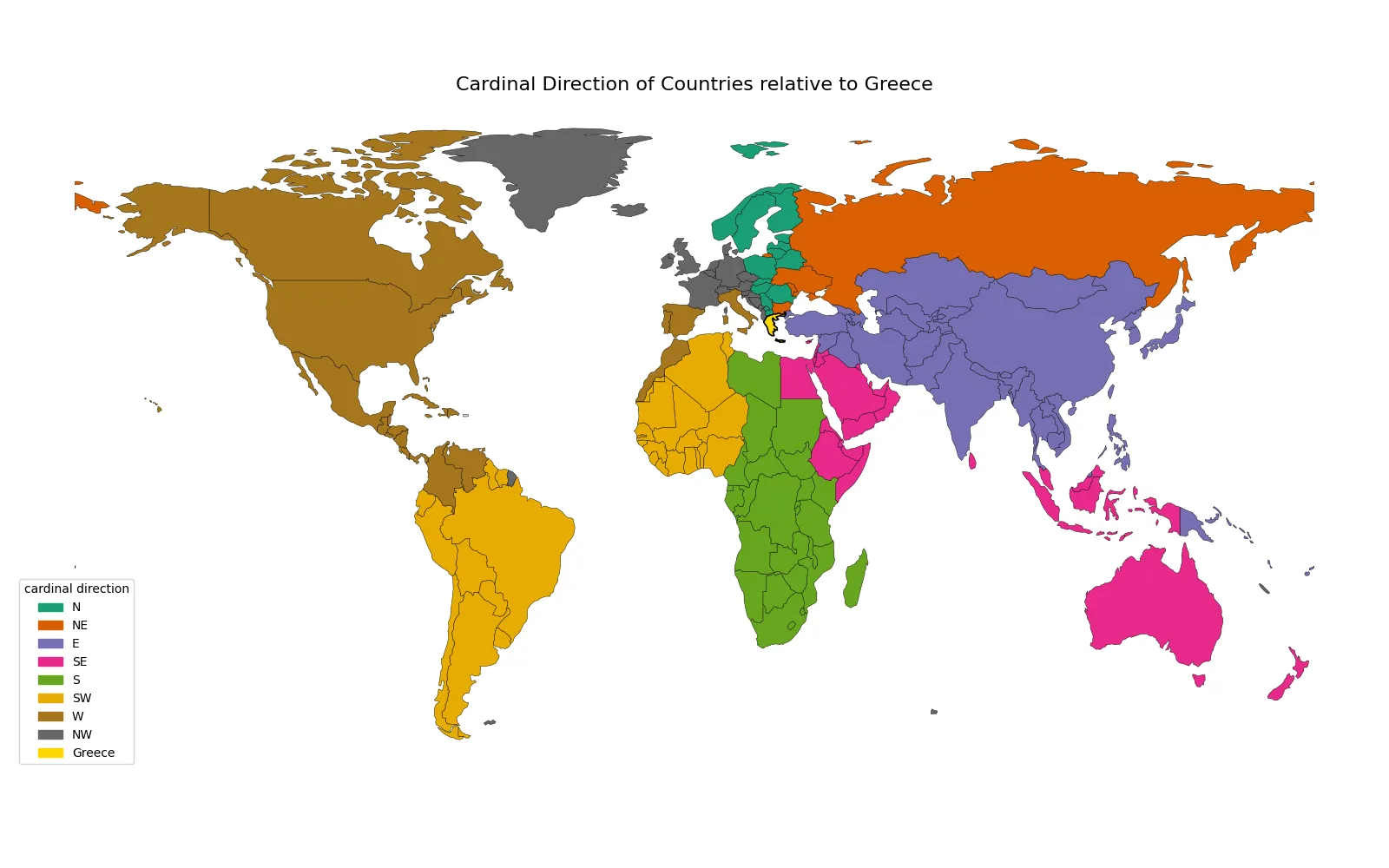
Directional feedback from Greece is unusually informative, which makes it a strong country for the coordinate module. Plate Carrée / Equirectangular projection.
Let's sidetrack a bit with loxodromes
The direction module turned out to be more complex than I expected. Countryle’s dataset gives one coordinate pair per country, based on some geographical centre calculation.
My first attempt to determine the direction used the great-circle route, the shortest path along the surface of the Earth. That sounds sensible, but it quickly produced unintuitive results. Great-circle paths bend heavily on a globe. A route from South Africa to Norway would initially head south toward Antarctica, even though we would normally say that Norway lies north of South Africa.
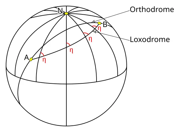
Loxodromes cross meridians at a constant angle. Credits: McSush for Wimikedia Commons
So I switched to rhumb lines, also called loxodromes and this is where the Mercator projection comes in handy. The projection was designed 1569 for navigation, rapidly adopted as the standard map projection, not for representing the world faithfully but it is still widely used, for example in Google Maps. Its key property is that it preserves angles locally, which means that a path with a constant compass bearing appears as a straight line on the map. Exactly what Countryle uses to determine the cardinal direction feedback.
However, preserving angles comes at a cost. Mercator severely distorts area, especially as you move toward the poles. Regions like Greenland or Antarctica appear dramatically larger than they actually are, while countries near the equator look comparatively smaller, understating large parts of the Global South, which can unintentionally reinforce misleading perceptions of global scale and importance. In reality, Africa is about fourteen times larger than Greenland, yet on a Mercator map they appear almost comparable in size.
I build this little globe to help me out on the next prediction.
So what's the best country to start with?
Once all five modules were working, I combined them into a single scoring pipeline. Each module computes an entropy score for a candidate guess, and the final score is a weighted combination of those values currently using equal weights.
The theoretical computation of entropy across al the modules led to most informative starting country being Libya balancing all the different feedbacks.
Simulating every possible game
Once the solver worked, I wanted more than one solve each day for my evidence. Thus, I simulated the entire game locally.
Countryle uses 197 countries. That means I can start from every country and target every country, summing up to 1972 = 38,809 games. Subtracting the games where starting and target country are the same, we are left with a total of 38,612 games to be simulated.
The headline result is surprisingly strong: with all modules enabled, the solver reaches the target in 2.85 guesses on average.
Not all feedback channels in Countryle are equally informative. When used on their own, the continent hint performs extremely poorly, requiring on average nearly 25 guesses to identify the target country. This is not surprising: even after learning the correct continent, dozens of countries can still remain. Population and temperature provide substantially more useful signals, reducing the average number of guesses to roughly seven. The directional information derived performs even better, bringing the average down to around four guesses.
Based on this, the most obvious next step is a proper weight search. So far I started with equal weights across modules, which is a reasonable baseline but not the optimum. A grid search or a more systematic optimization pass should enhance the solver. Since already the one run over all country pairs consumed a lot of compute, I refrained from doing this demanding grid search for now.


Libya is not the best starting country
Since Libya came out on top as the best starting guess, I also looked at its standalone performance in more detail. Unsurprisingly, it performs extremely well and leads to a very compact distribution of solve depths.
One especially interesting result appears when ranking opening countries by their average number of guesses across all targets. In fact, countries like the Republic of the Congo, the Central African Republic, Laos, Equatorial Guinea, and Gabon all perform even better.
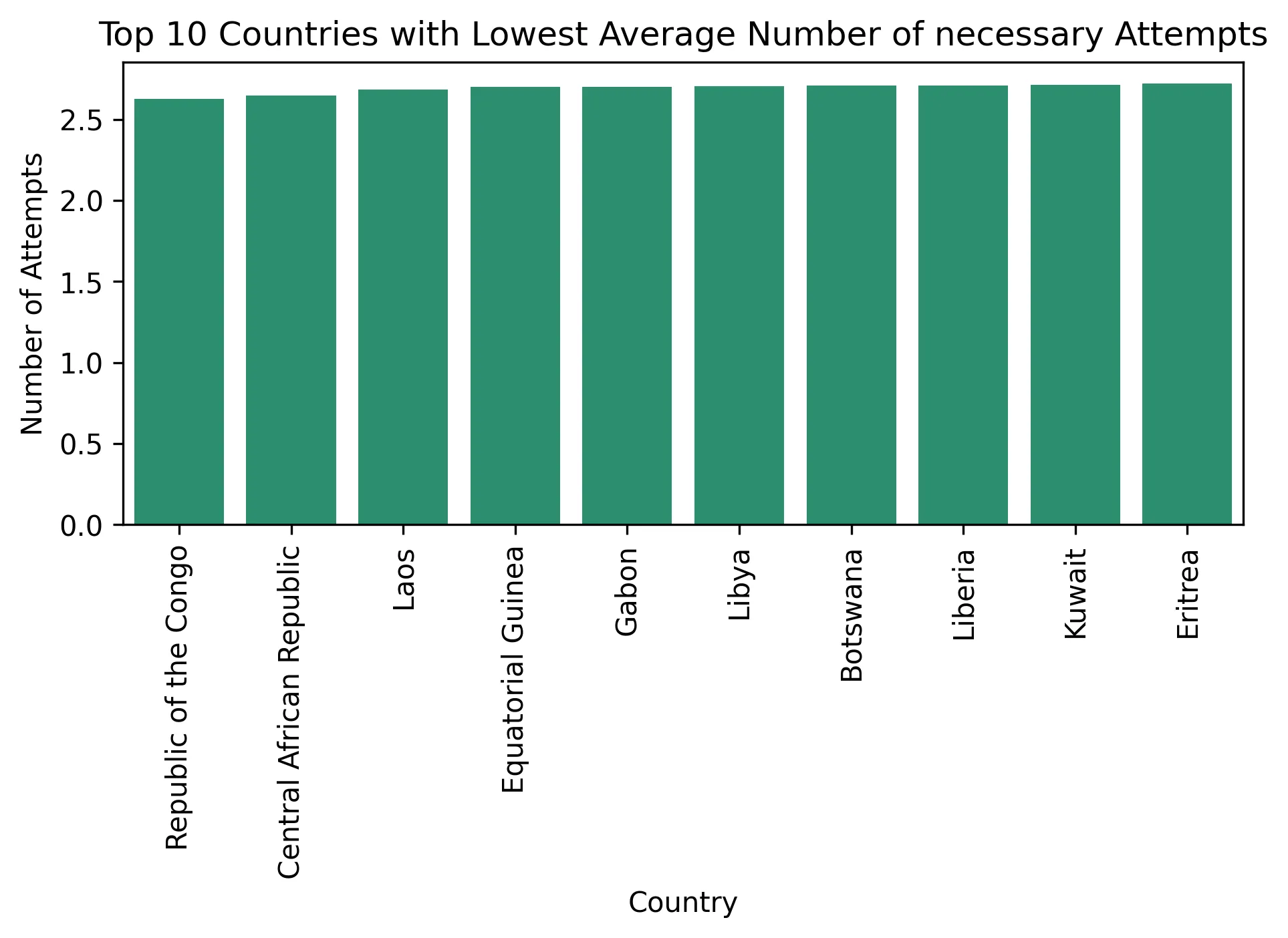
Some countries outperform Libya in average solve depth across all targets.
That sounds contradictory at first, but it points to something important: “best starting country” depends on the exact metric. Libya emerged as the best opener in my equal-weight combined entropy setup, while other countries can edge it out under average iteration rankings. Undermining that the equal weight entropy approach is in fact not optimal. I assume that these strong performers sit in regions that create useful splits for several modules at once. The entropy approach on the other side only looks on one feedback channel at a time not including interdependencies of the channels. They may not dominate every single feedback type, but they consistently avoid bad splits.
What comes next
The current solver already performs well, but there is still room for improvement. The most obvious next step is a proper weight search.
Another limitation of the current solver lies in how population and temperature are handled. Once the solver reaches the correct bucket, it loses information about whether the target lies toward the upper or lower edge of that range. Currently the solver simply iterates through the remaining countries in the bucket, but a better strategy would likely probe on bucket boundaries to narrow down the exact value of population or temperature.
At first, Countryle looked like a small easily solvable web game to me, but under the hood it became a neat little lab for entropy, search, geographic representation, and decision-making under uncertainty.
Niclas Stoffregen, 13.05.2026